Sunday, January 31, 2010

A ride through Deer Creek Canyon

Note: This posting is also located on examiner.com. So what's the difference?  I get paid per # of hits on that site, so if you feel like helping my fuel budget, read the article there instead:  LINK  Thanks!

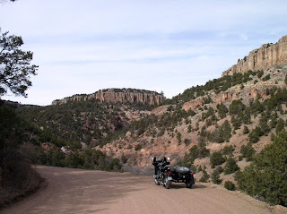
Deer Creek Canyon Road, located near the intersection of the E-470 Super Slab and Wadsworth Blvd, is one of my favorite twisty roads to ride when one is short of time.  It's close to the Denver metro area, well maintained and has beautiful rock formations to go with its curving turns that lead one northwest towards Turkey Creek Roads north and south, both ending up eventually at US285.

I was not able to leave the house to go riding till almost 1:00PM and so I chose the Deer Creek Canyon area to give Brigitta, my 1987 R80 Beemer Airhead motorcycle some exercise.  It had been over a month since I'd ridden her and my maneuvers reflected it!  My u-turns were awkward and wide in radius, my shifting was rough, and it took me some time to accustom myself to her controls once again.  Sure, the weather has been cold and not conducive to riding on a motorcycle with a minimalist fairing, but I was chagrined at my mistakes.  I can't imagine what it must be like for motorcycle riders who hibernate their motorcycles all winter!

Anyways, I made my way through the Town of Parker, using the Crowfoot Parkway to get to the outskirts of Castle Rock.  Crossing over the I-25 slab using Founder's Parkway, I was soon winging my way north on US85.  Brigitta ran sweetly and strongly, smoothly forging its way into the strong winds that would be my company throughout the entire ride. 

I continued past the town of Sedalia where a few Harleys were parked outside the bar there.  I got onto the Titan Parkway and headed now west, soon enough I was turning onto Waterton Canyon and slowly making my way to CO121.  I turned north when I got to CO121 and a few minutes later I was at the beginning of Deer Creek Canyon Road.

The roads were clear of gravel and I enjoyed a few of the twists and turns, going past the South Valley Park area, and turning left onto Grizzly Road looking for Deer Creek Canyon Park.  The park turned out to be an open space park, where you park your vehicle and go hiking.  This was not for me so I continued past and explored the surrounding area's beautiful rock formations.  Folks have made their homes amongst these rock formations, blending in nicely I thought and not being too disruptive to one's view of nature's beauty.

Now this is a good example of blending one's home with the surroundings


A closer view of the rock strewn landscape visible from the high points of Deer Creek Park

Leaving the neighborhood of Deer Creek Park, I wound my way back towards a large rock formation I'd spotted on the way in, right on Deer Creek Canyon Road.  It's a bit awkward to get one's motorcycle into position due to the blind curves on both ends of the formation but I managed to do it safely.
   
Looking west on Deer Creek Canyon Road

I got myself turned around once more and headed back towards CO121.  Turning north, I elected to use the E-470 slab to speed on home as it was now 36°F and I was getting a bit chilled.  There was some construction delays between University Blvd and Colorado but after that I was making my way home at a good clip, strong headwinds notwithstanding!

Pretty good ride today, a bit windy and cold, some rust on my two-wheeled riding skills that I must work to remove.  First thing being not letting a month go by before riding on two wheels, next some practice in parking lots on my u-turns.

Hope you got some riding in today.

EOM Mileages: Brigitta: 83,363  Natasha: 13,701 Km

Saturday, January 30, 2010

Meandering around Denver City Park

Note: This posting is also located on examiner.com. So what's the difference?  I get paid per # of hits on that site, so if you feel like helping my fuel budget, read the article there instead:  LINK  Thanks!

Today's riding was in sunny weather and temperatures which started for me in the high 20s and ended up in the mid-40s.  Very nice riding weather for Colorado in other words!

A couple of weeks ago, I'd visited the Denver Museum of Nature and Science, with my youngest son Miles.  The crowds had been horrific and we'd left hurriedly to cruise the nearby park.  The park turned out to be Denver's City Park, in which not only the museum resides, but also the Denver Zoo and Ferril Lake.  Just before escaping the crowds at the museum, I had seen a nice view of the boat pavilion on Ferril Lake with Denver's downtown skyscrapers in the background.  Today, I returned to City Park to capture the view:

The boat pavilion at Ferril Lake, with Mount Evans in the distance

Having accomplished the objective for today's ride, I was free to meander through the remainder of City Park to see what I could see.  As it was mid-morning while I rode around, the sunlight was doing some interesting lighting of the trees lining the roadways coursing through the park grounds.

 
 Some of the hundreds of geese I saw wandering and flying about the park

  
 I liked the way the sunlight played amongst the branches of these trees


 Natasha at Duck Lake, I wonder if all the nests you can see in the trees are occupied.

  
 A closeup view of the ducks and geese at Duck Lake

It's quite the nice park to take one's family to if you're a Denver resident.  I saw lots of parents pushing their young sitting in strollers, young ladies jogging and a few bicyclists riding slowly taking in the sights.  The park is apparently also a highly popular gathering point for geese.  I saw squadrons of them flying about and coming to rest in large flocks in the open areas of the park.

I made my way home for lunch, taking side roads back to my home neighborhoods.  It was getting a bit warm as I rode home, I had to remove the ATV grip covers from my handlebars and was seriously considering shedding a layer or two.  I think I'll be taking Brigitta out for a spin tomorrow, it's supposed to be a few degrees warmer than today!

Hope you got some riding in.....

Friday, January 29, 2010

Thursday, January 28, 2010

Ducati powered Bimota DB8 2010 Released

Ducati powered Bimota DB8 Released
Ducati Motor Sport Pain
London-The Italian motorcycle manufacturer Bimota officially released the entry-level motor sport that uses the engine Ducati DB8 recently.
Dual-seat motor is much cheaper and has lower specs than the DB7 but has a better engine power. Ducati 1198 engine carries DB8 testastretta evoluzione V4 90-degree twin, in contrast with the DB7, which brought the Ducati 1098 engine. Bimota DB8 claims can produce maximum power 168 hp at 9750 rpm and maximum torque of 97 ft-lb. 1198 DB8 machine used to deliver the sensation of driving and better performance.
If DB7 with carbon bodywork and subframe, DB8 uses plastic bodywork and aluminum subframe. Besides using titanium exhaust system DB7, DB8 uses steel exhaust.
DB8 equipped with lower-specced Extreme Tech Marzocchi fork and monoshock. DB8 is also equipped with Dunlop Sportmax GP Racer tires, while the DB7 using Continental Race Attack tires. Bimota DB8 dibandrol U.S. $ 33,127,cheaper than DB7 sold U.S. $ 37 533.

Motor cycle Photo : Funny animal with Rider


source
motor cycle with animal within thema.

Motor cycle Review : Yamaha V Max VMX17

Motor cycle Review : Yamaha V Max VMX17 - 2010 wallpaper

Motor cycle Review : Vespa Art Chooper Modification

For the fans there are several streams Vespa; there who love vintage, restaurants, and modification. So any modifications on the flow is divided again: british / mod style of asking the British scooterist style 60-70s era, modifications touring, racing modifications, modification of rat-bike, and last modification chopper.
Modifications chopper began to bloom in the early 2000s. This probably stems from the idea of a pocket scooterist mediocre but want to have a motor like a chopper.


source

Wednesday, January 27, 2010

Uraling down the Shelf Road on the Gold Belt Scenic Byway

Note: This posting is also located on examiner.com. So what's the difference?  I get paid per # of hits on that site, so if you feel like helping my fuel budget, read the article there instead:  LINK  Thanks!'

Back in August of 2009, I rode an interesting dirt road that is called Phantom Canyon Road, it was doable but at times challending when on two wheels.  After the ride, while reading up on the area, I found there was another road, called the Shelf Road which went from Cañon City to Cripple Creek, CO.

Shelf Road, carved out of the side of the canyon walls of Four Mile Canyon just north of Cañon City, used to be a stage coach road linking the mining towns in what was called the Gold Belt.  Yesterday, I decided to ride down to Cañon City and ride this road from its southern end to its northen end at Cripple Creek.

I left the house around 08:30 AM and made pretty good time down to Cañon City, getting there just short of 11:00 AM.  The weather was a bit "brisk" in that temperatures were in the teens to mid 20s at best.  Riding behind the big windshield of Natasha, my '96 Ural Sidecar Rig, I kept basically warm but had to engage the heated grips early on!


A view of Pikes Peak from CO83, perhaps 25 miles from the mountain itself

It warmed up into the high 30s and low 40s as I wandered for a bit within Cañon City trying to find the way to Shelf Road; it felt positively balmy!  You have to find the intersection of Central Street and Field Avenue.  Take Field Avenue north out of the city and you're on your way.  You can also visit Red Rock Canyon Park which is along Field Avenue which becomes Road #9.

Pretty soon, you'll see BLM (Bureau of Land Management) signs designating the way and start of the Shelf Road.  Here's some of the pictures I took along the portion of the road which at this point spans Four Mile Canyon; the road is literally carved out of the side of the mountains..


My first view of the Shelf Road


I wasn't making much forward progress, every bend in the road was a photo opportunity!


You can see the Shelf Road, carved out of the mountainside


The road conditions as I transited Four Mile Canyon were pretty good, just hard packed dirt and small rocks and some gravel.  The road descended to a small bridge spanning Four Mile Creek.  There was a sign at this point saying that the road ahead was: "Rough Road, 4WD or vehicles with high clearance recommended" or something along those lines.  Just before I saw the sign, I had been thinking how "smooth" the road had been, this would now change.

As I ascended along the now rougher portion of Shelf Road, I had to keep my speeds down as large rocks which were embedded in the dirt road were causing Natasha to bounce a lot if I went too fast.  Still, the road was not bad for my rig.  It surely was not as bad as some of the spots I'd ridden my two wheel motorcycle through on the Alpine Loop Road in southwestern Colorado!

Still, I definitely had to go slower than when on the 4 Mile Canyon portion of Shelf Road.  There, what had kept my speed down was the fear of losing traction/control on some bend and going off the side of the mountain as there are no guard rails!  Some of the views down into the valley below were slight vertigo-inducing.

The northern half of the Shelf Road is not as dramatically hewn out of the side of mountains as its southern half.  Still, it's quite beautiful with its pine trees clinging to the high canyon walls. 


Window Rock


The shelf road behind Window Rock

There were less photo opportunities on the northern half of the Shelf Road and I was kept busy making sure I had the right gear in place as the sloping/curving road demanded my attention.  Lots of rocks and holes, so while not too bad, it's not a road you want to take a low-slung car through!  There were also more stretches of road where I had to stand on the pegs to take my weight off the motorcycle's suspension.

About 5 miles from Cripple Creek, I stopped Natasha on the road to get this stretch of the road which still had some snow along the sides:


Natasha had been running a bit rough after leaving the bridge crossing Four Mile Creek but I had attributed it to the steep grades and rough road conditions.  As I went to start her, the engine would not catch!  The starter would just turn and turn with no ignition of the engine.

After the initial panic of being out in the middle of nowhere passed.  I started troubleshooting procedures.  I even thought to try and turn her around and use the downward slope of the road to kickstart her.  All I managed to do then is get her rear tire wedged in the small snow bank on the right side of the road!

After verifying I had spark and plenty of juice in the battery, I next verified both carburetors were getting fuel.  So, I had spark, I had fuel, next critical component was air for the air/fuel mixture.  I removed the airbox cover and took out the paper air filter I'd been using for a few weeks.  It was quite dirty and coated in soot and oil!

Leaving the air filter out, I tried the starter and lo and behold she started right up!  The engine had not been getting enough air for the air/fuel mixture!  I had known that the design of the airbox on the Urals left much to be desired and so I carried a spare air filter.

A pickup truck had pulled up at this point and had been looking at me working on the air filter.  No talking, just staring, no offer to help.  The guy just sat there so I ignored him as I replaced the dirty filter with the spare one.  I was blocking the road partly at this point so I was hurrying.  I guess I didn't move fast enough as he decided to edge around me to get by.  The idiot came within three inches or so of the edge of the road, had it given way, he would have plummeted a good 50 feet into the creek bed!

But he made it and without even a backward look, drove away.  I finished buttoning up Natasha and putting away my tools and keep on riding.  I never did catch up to him, perhaps someday he'll be broken down on the side of the road and people will just pass him by without offering to help.

I made it to Cripple Creek just fine, checked in with my loving wife and started heading home.  From Cripple Creek, I got on CO67 heading north till it junctioned with US24 a short ways west of Wood land Park.  Once past Woodland Park, I soon was back in Colorado Springs and after a short sprint on the I-24 super slab northbound, made it back to CO83 via the Interquest Parkway.

Got home right at 4:30 PM, so about 7 hrs of saddle time and roughly 250 miles of riding.  Other than the clogged air filter, Natasha did fine!


Here's a topo map of the Shelf Road and Phantom Canyon Road

source:  LINK

More info on the Shelf Road and The Gold Belt Scenic Byways her and here

My previous ride on Phantom Canyon Road

Sunday, January 24, 2010

Windy Plains

Though sunny at times, today was mainly a blustery and windy day for riding.  The temperatures stayed below 39°F and it felt colder than that.

Once geared up and ATGATT though, the feeling of cold was minimal.  Mostly on my hands which were inside my winter gloves, the gloves were inside the ATV grip covers on Natasha, my '96 Ural Sportsman.  I never had to turn on the heated grips however, the hands just felt "cool".

After running an errand, I wandered over to the undeveloped rolling prairie lands near my home neighborhoods.  All the snow was gone, and what mud had developed had pretty much dried up in the cold sunny weather we've enjoyed the last few days.

It was late afternoon when I got there, pretty close to 4:00 PM as the "golden hour" started.  You'll have to imagine the mildly howling winds coming from the west, it made me have to retake shots at times since it would try to push me over as I framed the shot.


As close as I cared to get to the reservoir today, this is a new trail, led to a cul-de-sac in the making


Down in a low area, the reservoir is behind Natasha


Atop a small hill, you can see the Aurora Reservoir in the distance


Looking towards the south, the distant clouds looked like snow-capped mountain ranges

I rolled on towards home, stopping at a friend's house to pick up my youngest son from his "play date" with school chums.  I got him bundled up good, helmet on, and off we went towards home and warmth.

Hope you got some riding in today....

Previous rides in this area:

A short ride through the rolling plains
Riding a grassy trail to the lake

Saturday, January 23, 2010

Uraling to Eldorado Canyon State Park

Note: This posting is also located on examiner.com. So what's the difference?  I get paid per # of hits on that site, so if you feel like helping my fuel budget, read the article there instead:  LINK  Thanks!'

Today's ride I elected to stay close to the Denver Metro area and revisit the Eldorado Canyon State Park. The park is next to the small settlement of ElDorado Springs and Eldorado Mountain. The closest big city is Boulder and you get to it via CO93 and taking CO170 west into the foothills south of Boulder.

The main "road" through the settlement is dirt with lots of small potholes and rocks, so it's easy to keep with the posted 10 mph speed limit signs. The main attraction of the place is the Eldorado Pool Center, I imagine its quite popular in the heat of summer.

Just past the end of the settlement is the entrance to the Eldorado Springs State Park, a popular rock-climbing and hiking location for the folks who live in Boulder and Golden.

The entrance fee is $6 and the park is one main dirt road, narrow with high rocky canyon walls on both sides and a small creek running alongside the main road. At the end of the main road lies the park's visitor center.


Visitor Center


 A view of the rock-climbing formation which makes this park a popular destination


The view from near the visitor center, just before the trail that leads to picnic areas to the right


Picnic areas are behind Natasha, they give one a view of the frozen creek above, the area was closed to everyone though today.  Guess they figured correctly no one would be doing a picnic today!


This is the view of the gap provided by the Eldorado Canyon through the foothills south of Boulder


Getting back on CO93 from CO170, now heading south towards Golden and CO119, one gets a nice view of the Flatirons, the name of the rock formations near Boulder


Eldorado Mountain


In the middle of the photo is the entrance to Eldorado Springs

As I rode south on CO93, I spied some large wind power structures to the East.  I made my way closer and found they belonged to the National Renewable Energy Lab (NREL)'s Wind Technology Center.  It was pretty wind in this part of CO93 so I guess it was a good spot to test the various models of wind-powered turbines as any.


 One last shot of the Flatirons and Eldorado Mountain


NREL's Wind Technology Center

Continuing south on CO93, I turned onto Indianhead Road, which leads to someones ranch.  It's for sale folks!  This is the view you get as you drive out of your driveway to get to CO93:


Far as I can determine, this cool looking rocky ridge which lies just north of the intersection of Indianhead Rd and CO93 is unnamed.

Looking for more photo opportunities, I rode towards Golden and turned to go west on CO119.  The sun was too low in the sky though and there was no sunlight really hitting the rocky canyon walls along this curvy and twisting two lane road.  Lots of cagers though, I kept having them stack up behind me (even though I was riding at or slightly above the speed limit).  So I'd keep pulling over to let them pass so I could ride and still enjoy the scenery.

I gave up trying to find good photo ops and turned around at the "slow vehicle turnout" just west of Tunnel #3 on CO119.  Before I got going though, I made my way to a tourist information sign I'd not spotted before on my rides through this part of Colorado.  It turned out to have some information that peaked my interest as it pertained to the role of the Chinese in Colorado History:


My father tells me that my great-great grandfather came to America during the mid 1800s to work on the railroads, I wonder if he heard about Chin Lin Sou?

Heading back towards Golden on CO119, I found a good spot to stop between Tunnels #3 and #2 for this shot of frozen over Clear Creek:


Clear Creek

Resuming my ride towards Golden, there were no further photo ops and I just made my way south past Golden and got on Morrison Rd at the town of Morrison.  I filled up with gas at the Conoco station there and got UDF'ed a local police officer.  UDF over, I continued east on Morrison Rd till I got to Kipling Blvd which I took south to its junction with US285.

I was home by 3:00PM, having ridden a mere 204 Km's or about 120 miles in about five hours of saddle time.  I don't think the temperatures got above 40 degrees the whole time I was out, still it was a good day of riding.